It is well known that Kelvin and gravity waves in the tropics cause temperature perturbations in the tropical tropopause layer (TTL), and that in the cold wave anomalies we can expect to find more cirrus clouds. However, Kim et al (2016) found that, in aircraft observations, cloud ice was found more frequently in a specific portion of the cold anomaly. Figure 1a shows a temperature profile from FORMOSAT-3/COSMIC, and its corresponding base state of the atmosphere. The difference between the two, shown in Figure 1b, is the wave anomaly. As you can see, the cold anomalies (blue) can be divided into two portions, the "bottom" portion, characterized by dT'/dz<0, and the "top " portion, which has dT'/dz>0. Kim et al. (2016) (https://doi.org/10.1002/2016GL069293) made an interesting finding that the "bottom" portion tends to contain vastly more cloud ice than the "top" portion. This peculiar feature interested me, and I wanted to explore whether this was a general feature of TTL clouds.

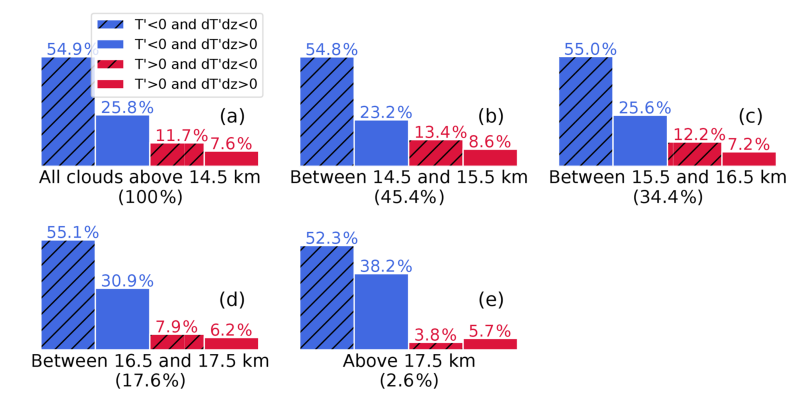
By utilizing the FORMOSAT-3/COSMIC temperature profiles in conjunction with TTL clouds extracted from CALIPSO data, I assessed the cloud occurrence frequency in each of the wave phases shown in Figure 1b. Indeed, over 50% of TTL clouds were inside the "bottom" portion of cold anomalies, as shown in Figure 2. As the work of Kim et al. (2016) was based on in-situ observations over the Pacific, our results builds upon their work, showing that the high frequency of clouds inside the phase of T'<0 and dT'/dz<0 is a general tendency of TTL clouds.

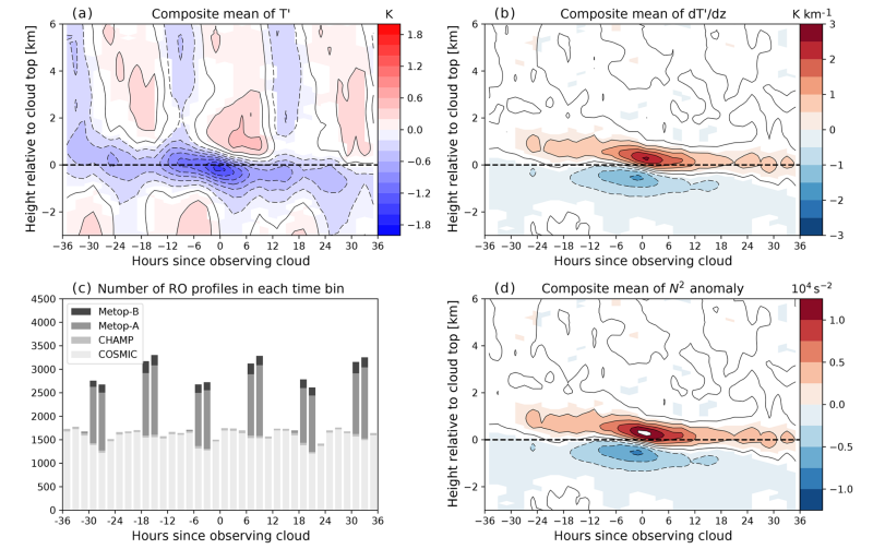
How do we know that these anomalies are actually Kelvin or gravity waves? This can be inferred by the behavior of the cold anomaly over time, as shown in Figure 3. These figures were derived by averaging the temperature anomalies with respect to the cloud top altitude. In Figure 3a, we can see that there tends to be a strong cold anomaly occurring starting from -18 hours since the time of observing the cloud. Over time, this cold anomaly tends to descend in altitude. This is characteristic of upward-propagating Kelvin or gravity waves, whose wave phases propagate downward. Hence, it is likely that the anomalies we observe are indeed from Kelvin or gravity waves. Figure 3b depicts the structure of dT'/dz relative to the cloud top (dashed line), showing that below the cloud top, the sign of dT'/dz tends to be negative. That is, on average, TTL clouds tend to be embedded in the "bottom" portion of cold anomalies.


